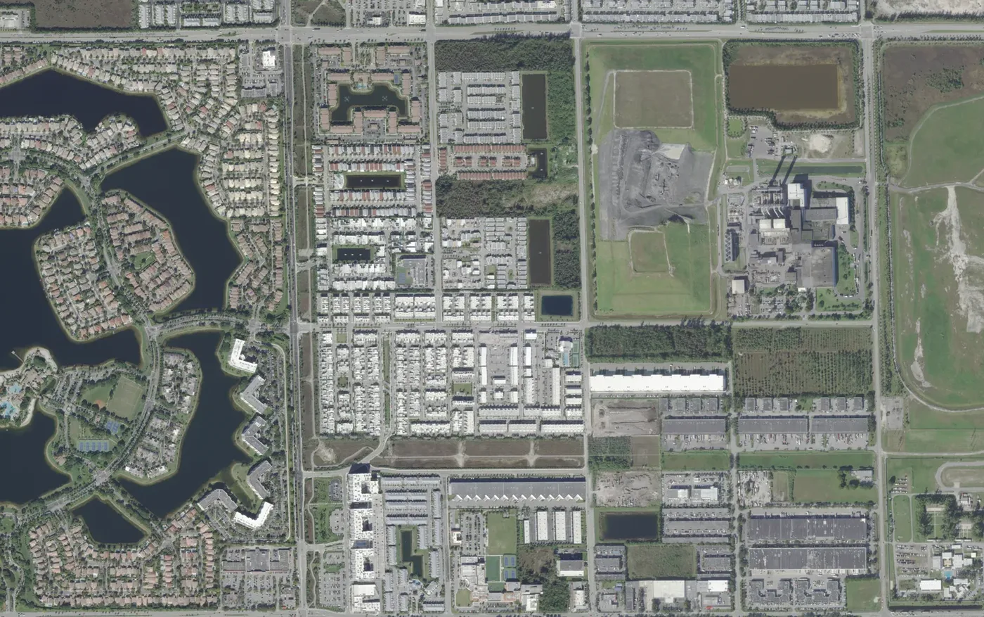
LandMark and Vintage Estates, between NW 58th and NW 74th streets, have 1,522 homes in ZIP 33178 zoned for Ronald W. Reagan/Doral Senior High.
Last checked Oct. 8, 2026. Sources: the City of Doral’s community map and comprehensive plan (PDF), the Property Appraiser of Miami-Dade County’s parcel data, Miami-Dade County’s school attendance zone maps, the Florida Department of Education’s 2026 school grades, Zillow Research, Miami-Dade Transit and OpenStreetMap.
This is the middle of north Doral: NW 97th to NW 107th avenues, between NW 58th and NW 74th streets. Most of its homes are new. LandMark at Doral, the largest community, has townhouses, condominiums and an apartment complex around lakes, and Vintage Estates, Doral Cay and smaller communities sit around it. The east side, along NW 97th Avenue, is business parks and a county solid waste plant.
What this means for you
- Zoned high school: Ronald W. Reagan/Doral Senior High, for every home in the county’s zone map. Check your address in the district’s SchoolFinder.
- Home value: $553,694 in ZIP 33178 in August 2026, according to the Zillow Home Value Index.
- Nearest expressway: Florida’s Turnpike exit 31, NW 74th Street.
Part of our Doral neighborhoods guide.
Where it is
The city’s community map names the residential communities here: LandMark at Doral, at about 122 acres, Vintage Estates, Doral Cay, Mansions at Doral, Neovita North, Neovita South and Atlantic at Doral. The county’s plat records add Doral Palms North and South and Grand Floridian Estates, and list business parks such as Flightway and Doral Edge to the east. OpenStreetMap maps a shopping center, The Shops at Landmark, near NW 105th Court and NW 58th Street.
On the east side, at 6990 NW 97th Ave., is a 157-acre county-owned property that the Property Appraiser’s records describe as a solid waste recovery plant. The city’s comprehensive plan asks the county to add a buffer along the plant’s west edge at NW 102nd Avenue.
The Property Appraiser’s records list 1,522 homes: 815 townhouses, 408 condominium units and 299 single-family homes. Another 991 apartments sit in two rental complexes, at LandMark at Doral and Atlantic at Doral. Every home was built in 2013 or later, 14% of them since 2020. All are in ZIP code 33178.
Schools
Shares are of the area’s home parcels in Miami-Dade County’s attendance zone map. Grades are the state’s 2026 school grades.
| Level | School | Share of homes | 2026 grade |
|---|---|---|---|
| Pre-K to 4 | Andrea Castillo Preparatory Academy, 10201 NW 78th St. | 100% | A |
| Middle (zone map) | Ruben Dario Middle, 350 NW 97th Ave., Miami | 100% | A |
| High | Ronald W. Reagan/Doral Senior High, 8600 NW 107th Ave. | 100% | A |
The federal NCES directory lists Andrea Castillo Preparatory Academy with grades pre-K to 4. The county’s middle school map places all of Doral, including this area, in Ruben Dario Middle’s zone. A public charter school, Doral International Academy of Math and Science, kindergarten to eighth grade, is in the area at 6700 NW 104th Ave. More in our schools guide.
Home values
The typical home value in ZIP 33178 was $553,694 in August 2026, down 1.07% from $559,660 in August 2025, according to the Zillow Home Value Index. The index is a modeled typical value for the middle third of homes, not a sale price. ZIP 33178 covers most of Doral; Zillow’s index for the whole city was $543,159, down 1.16% on the year. More in our home prices guide.
Parks and trails
The city’s parks list has no park inside this area. The nearest are:
- Doral Glades Park, 7600 NW 98th Place, just north of NW 74th Street: about 25 acres with a nature center, a fishing pier, a kayak launch, tennis, pickleball and sand volleyball. Phone: 305-593-6638.
- Doral Meadow Park, 11555 NW 58th St., west of NW 107th Avenue.
More in our parks and trails guide.
Getting around
- Expressways: Florida’s Turnpike exit 31 is at NW 74th Street, by the exit numbers in OpenStreetMap.
- City Hall: about 2.9 miles from the middle of the area by road.
- Airport: about 9.7 miles to Miami International Airport. Both are distances measured on the OpenStreetMap road network with the OSRM routing engine, not drive times.
- Doral Trolley: Route 3 and the FIU route stop along NW 104th and NW 107th avenues, including Doral Isles Plaza and Doral Commons, according to Miami-Dade Transit’s schedule data. See the city’s trolley page.
- Metrobus: no route stops inside the area.
More in our getting around guide.
Homeowners associations and districts
The Property Appraiser’s non-ad valorem assessment list (PDF) names the Landmark at Doral Community Development District. A CDD’s assessment appears on the tax bills of the parcels inside it. See our property tax guide.
Groceries and everyday stores
From OpenStreetMap:
- Aldi, 5875 NW 105th Court, at The Shops at Landmark
- CVS Pharmacy, 10700 NW 74th St.
- Publix, 10715 NW 58th St., across NW 107th Avenue in Doral Isles Plaza
How we drew this area
The edges follow NW 58th Street, NW 74th Street and NW 97th and NW 107th avenues, and are approximate. Home counts and school zones come from every home parcel inside them in the Property Appraiser’s records and the county’s attendance zone layers, checked Oct. 8, 2026. Store locations are © OpenStreetMap contributors.
Frequently asked questions
Is LandMark at Doral a good place to live?
Here are the facts. LandMark and Vintage Estates are the area between NW 97th and NW 107th avenues from NW 58th to NW 74th Street, with 1,522 homes, all built since 2013, and about 990 apartments. It is zoned for Ronald W. Reagan/Doral Senior High, graded A for 2026, and Zillow put the typical value in ZIP 33178 at $553,694 in August 2026.
What elementary school is LandMark at Doral zoned for?
Andrea Castillo Preparatory Academy, for every home in the area in Miami-Dade County’s attendance zone map. Check one address in the district’s SchoolFinder.
Is there a community development district in LandMark at Doral?
Yes. The Property Appraiser lists the Landmark at Doral Community Development District, whose assessment appears on the tax bills of the parcels inside it.
What is the plant on NW 97th Avenue in Doral?
A 157-acre county-owned property at 6990 NW 97th Ave. that the Property Appraiser’s records describe as a solid waste recovery plant. It sits on the east side of this area.
Have your say