Doral's 10 residential areas, from Downtown Doral to the Islands at Doral: ZIP codes, zoned schools and August 2026 Zillow values, with a map.
Last checked Oct. 8, 2026. Sources: the City of Doral’s Neighborhoods and Communities map and comprehensive plan (PDF), the Property Appraiser of Miami-Dade County’s parcel data, Miami-Dade County’s school attendance zone maps, the Florida Department of Education’s 2026 school grades, Zillow Research, the Census Bureau and OpenStreetMap.
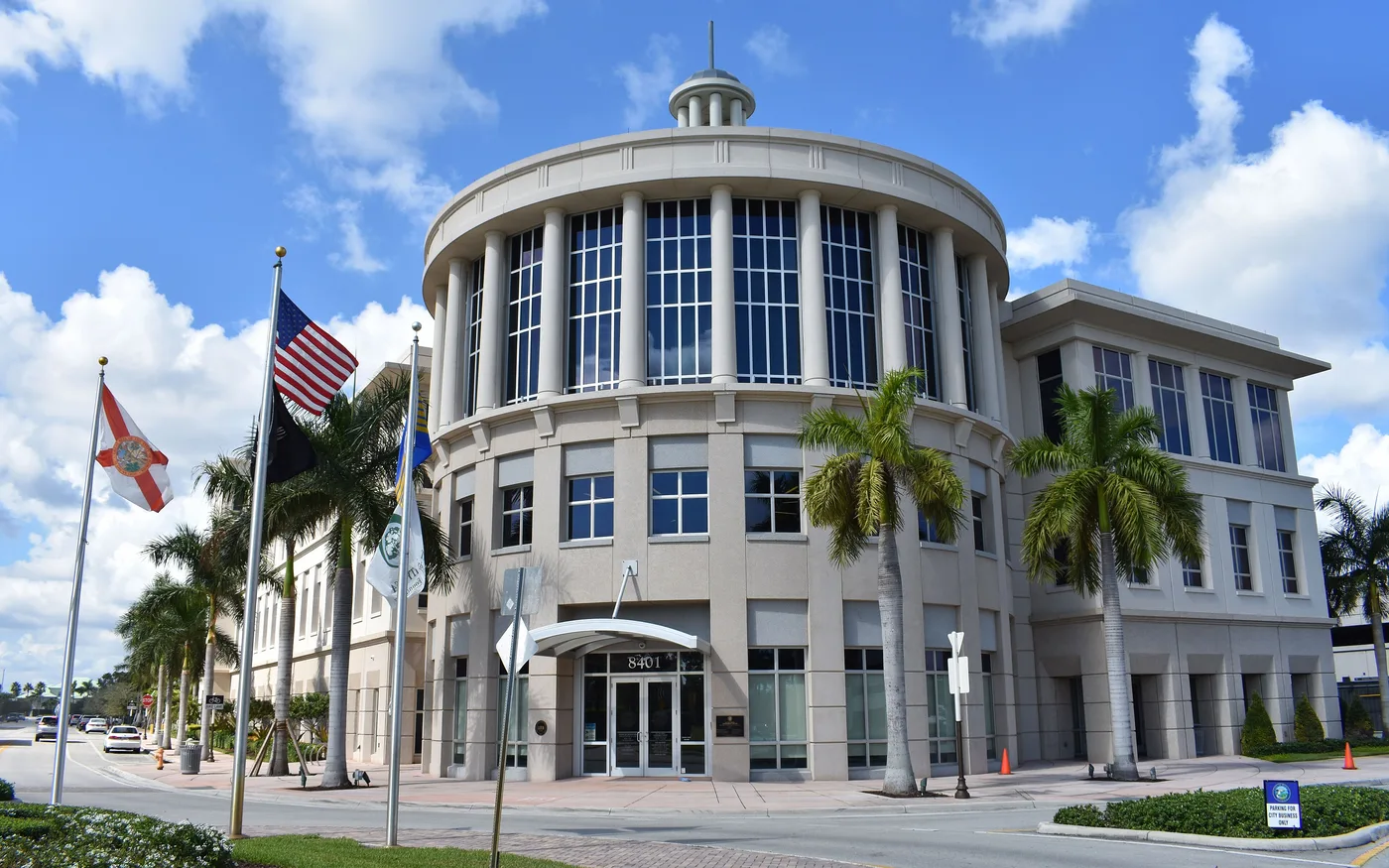
Doral is a city of 79,216 people in western Miami-Dade County, according to the Census Bureau’s 2020-2024 American Community Survey five-year estimates. It is laid out on the county’s street grid: numbered streets run east and west, numbered avenues north and south. Florida’s Turnpike runs along the western city line, the Palmetto Expressway (State Road 826) along the eastern edge, and Doral Boulevard (NW 36th and NW 41st streets) through the middle. City Hall is in the Government Center at 8401 NW 53rd Terrace, in Downtown Doral.
Most of the city’s homes are north of Doral Boulevard and west of NW 87th Avenue. South of NW 25th Street, and along the east side near Miami International Airport, Doral is mostly warehouses, offices and showrooms.
Three things to know before you look at a listing:
- One city, five ZIP codes. The county’s parcel records put Doral homes in 33178, 33166, 33172 and 33122; a fifth, 33126, holds 220 Doral parcels, none of them homes. Zillow files 33166 under Miami Springs, 33172 under Fontainebleau and 33122 under Miami, because those ZIP codes cross city lines. Check that a parcel is inside Doral with the Property Appraiser’s property search before you count on Doral police and city services.
- Two high school zones. Miami-Dade County Public Schools zones the south and east of the city to J.C. Bermudez Doral Senior High and the north to Ronald W. Reagan/Doral Senior High, in the county’s attendance zone map. Always check one address in the district’s SchoolFinder.
- Mostly condos and townhouses. Of the 23,571 homes the Property Appraiser lists in Doral (counting each condominium unit), 49% are condominium units, 25% townhouses and 26% single-family homes, including cluster homes. Another 8,995 apartments sit in 32 rental complexes.
The areas at a glance
School zones are the county’s attendance zone map, measured at the area’s home parcels. Home values are the Zillow Home Value Index for August 2026: a modeled typical value for the middle third of homes in the whole ZIP code, not a sale price. The citywide Doral figure was $543,159.
| Area | Main ZIP code | Zoned high school | Typical value, main ZIP |
|---|---|---|---|
| Downtown Doral | 33166 | J.C. Bermudez Doral | $604,072 |
| CityPlace and Doral Central Park | 33172 and 33122 | J.C. Bermudez Doral | $296,043 (33172) |
| Doral Estates | 33178 | J.C. Bermudez Doral | $553,694 |
| Costa del Sol and Vanderbilt Park | 33178 and 33172 | J.C. Bermudez Doral | $553,694 (33178) |
| Morgan Levy Park area | 33178 | J.C. Bermudez Doral | $553,694 |
| Doral Meadows | 33178 | J.C. Bermudez Doral | $553,694 |
| Doral Isles | 33178 | Reagan/Doral (90%), Bermudez | $553,694 |
| LandMark and Vintage Estates | 33178 | Reagan/Doral | $553,694 |
| Islands at Doral | 33178 | Reagan/Doral | $553,694 |
| Midtown Doral and Grand Bay | 33178 | Reagan/Doral | $553,694 |
Map of the areas
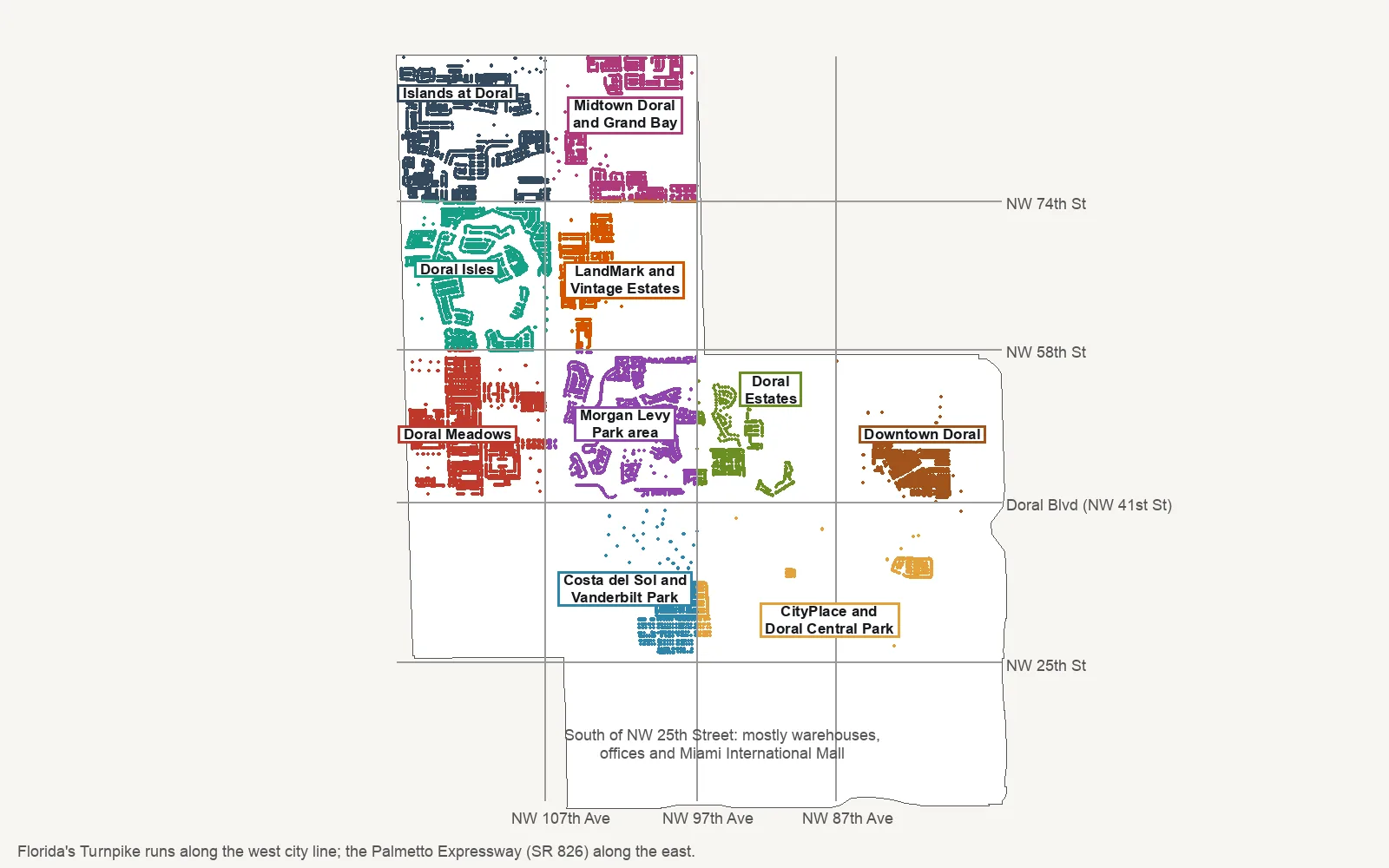
Map by Doral Now. City limits are from the City of Doral’s city limits layer; the dots are home parcels in the Property Appraiser of Miami-Dade County’s records. Road lines are approximate.
Downtown and the east side
Downtown Doral. East of NW 87th Avenue between Doral Boulevard and NW 58th Street: the Government Center, Downtown Doral Park and the mixed-use district the city’s comprehensive plan calls its “Urban Central Business District.” It has the most homes of any area here, 77% of them condominium units.
CityPlace and Doral Central Park. South of Doral Boulevard and east of NW 97th Avenue, around the CityPlace Doral shopping center and Doral Central Park. Mostly offices and warehouses, with a few hundred homes and about 2,200 apartments.
Doral Estates. NW 87th to NW 97th avenues, north of Doral Boulevard, around the golf courses of Trump National Doral. Condominiums and homes mostly built in the 1980s and 1990s.
Central Doral
Costa del Sol and Vanderbilt Park. South of Doral Boulevard between NW 97th and NW 107th avenues, around the Costa del Sol golf course. Homes here date mostly from the 1980s and 1990s.
Morgan Levy Park area. NW 97th to NW 107th avenues, north of Doral Boulevard, named for the city park at its center. Townhouses, condominiums and cluster homes from the late 1980s and 1990s.
Doral Meadows. West of NW 107th Avenue up to NW 58th Street, with J.C. Bermudez Doral Senior High, Trails & Tails Park and several large apartment complexes.
North Doral
Doral Isles. West of NW 107th Avenue between NW 58th and NW 74th streets: the lake-ringed sections the county’s plat records name Doral Isles, built around 2000, plus Doral Meadow Park.
LandMark and Vintage Estates. NW 97th to NW 107th avenues between NW 58th and NW 74th streets. Every home was built in 2013 or later.
Islands at Doral. North of NW 74th Street and west of NW 107th Avenue, with Doral Legacy Park and Ronald W. Reagan/Doral Senior High.
Midtown Doral and Grand Bay. North of NW 74th Street between NW 97th and NW 107th avenues, with Doral Glades Park. The newest area in the city: 93% of its homes were built in the 2010s.
Comparing Doral with its neighbors
Taxes, schools, home values and commutes for Doral and its three nearest city neighbors, side by side: Doral vs Sweetwater vs Miami Springs vs Hialeah Gardens. For the citywide market, see our home prices guide; for every school, our schools guide. Getting set up: moving here and property taxes.
How we built this
We named only areas a public source places on a map:
- The City of Doral’s community map. The city’s GIS Neighborhoods and Communities layer names more than 140 residential communities, from Adagio to Windward. Each area here groups the communities between the same main roads.
- The comprehensive plan. The city’s plan, updated March 23, 2022, defines the Urban Central Business District downtown and the Downtown Doral Art District.
- County plat names in the Property Appraiser’s parcel records, such as Doral Isles, Islands at Doral, LandMark at Doral, Grand Bay and Midtown Doral.
- OpenStreetMap, which names Downtown Doral as a neighborhood and Vanderbilt Park as a place.
Area edges follow the main roads and are approximate. School zones come from Miami-Dade County’s attendance zone layers, last edited by the county in June 2025; the district’s SchoolFinder is the authority for any one address. The Property Appraiser’s non-ad valorem assessment list (PDF) names nine community development districts with Doral in their names, which add a charge to some tax bills; each area page names the ones that match it. Store and place data are © OpenStreetMap contributors.
Frequently asked questions
What are the neighborhoods in Doral?
Our guide covers 10 residential areas: Downtown Doral, CityPlace and Doral Central Park, Doral Estates, Costa del Sol and Vanderbilt Park, the Morgan Levy Park area, Doral Meadows, Doral Isles, LandMark and Vintage Estates, the Islands at Doral, and Midtown Doral and Grand Bay. The names come from the City of Doral’s community map, county plat records and OpenStreetMap.
What ZIP codes are in Doral?
Most Doral homes are in ZIP code 33178. Downtown Doral is mostly 33166, and parts of the area south of Doral Boulevard use 33172 and 33122. Zillow files 33166 under Miami Springs and 33172 under Fontainebleau because those ZIP codes cross city lines.
Which high school is Doral zoned for?
Two Miami-Dade County Public Schools high schools serve Doral homes. In the county’s attendance zone map, J.C. Bermudez Doral Senior High covers the south and east of the city and Ronald W. Reagan/Doral Senior High covers the north. Both earned an A in Florida’s 2026 school grades.
Do Doral school zones follow city limits?
Not exactly. The elementary and K-8 zones are drawn by the school district, not the city, and one area can be split between two schools. Check any address in the district’s SchoolFinder.
Have your say